
Fájl:UA232map.png

Az előnézet mérete: 800 × 581 képpont További felbontások: 320 × 232 képpont | 640 × 465 képpont | 1 024 × 744 képpont | 1 280 × 929 képpont | 2 567 × 1 864 képpont.
Eredeti fájl (2 567 × 1 864 képpont, fájlméret: 60 KB, MIME-típus: image/png)
|
Ez a fájl a Wikimedia Commonsból származik. Az alább látható leírás az ottani dokumentációjának másolata. A Commons projekt szabad licencű kép- és multimédiatár. Segíts te is az építésében! |
Összefoglaló
| Leírás |
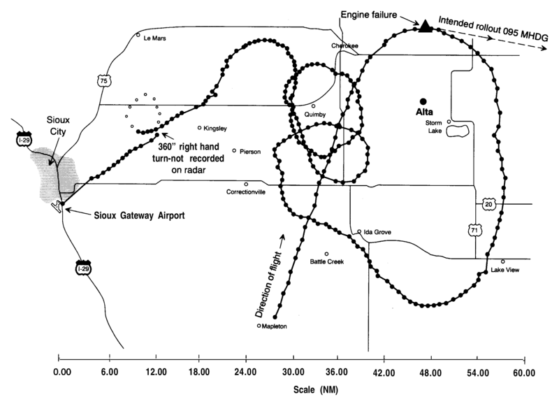
English: A radar map from the NTSB report into United Airlines Flight 232 crash. This shows all the known radar locations of the DC10 involved before its crash landing at Sioux Gateway Airport. |
| Dátum | |
| Forrás | NTSB accident report |
| Szerző | NTSB |
Licenc
This image is a work of a National Transportation Safety Board employee, taken or made as part of an employee's official duties. As a work of the U.S. federal government, all NTSB images are in the public domain in the United States.
|
Eredeti feltöltési napló
Áthozta Atmoz az en.wikipedia projektből a Commonsba CommonsHelper használatával.
Az eredeti leírólap itt volt. Az itt következő felhasználónevek az en.wikipedia projektre hivatkoznak.
- 2006-09-06 14:39 John 1005×702× (29356 bytes) Radar map from NTSB report into UA 232 crash
Fájltörténet
Kattints egy időpontra, hogy a fájl akkori állapotát láthasd.
| Dátum/idő | Bélyegkép | Felbontás | Feltöltő | Megjegyzés | |
|---|---|---|---|---|---|
| aktuális | 2017. szeptember 3., 02:16 | | 2 567 × 1 864 (60 KB) | Mikhail Ryazanov | original resolution from PDF |
| 2010. május 5., 05:04 |  | 1 005 × 702 (29 KB) | Atmoz | {{Information |Description={{en|Radar map from NTSB report into UA 232 crash}} |Source=Transferred from [http://en.wikipedia.org en.wikipedia]; transferred to Commons by User:Atmoz using [http://tools.wikimedia.de/~magnus/commonshelper.php CommonsHelp |
Fájlhasználat
Az alábbi lapok használják ezt a fájlt:
Globális fájlhasználat
A következő wikik használják ezt a fájlt:
- Használata itt: en.wikipedia.org
- Használata itt: fr.wikipedia.org
- Használata itt: it.wikipedia.org
- Használata itt: ja.wikipedia.org
- Használata itt: nl.wikipedia.org
- Használata itt: pt.wikipedia.org
- Használata itt: ru.wikipedia.org