
Fájl:Special member state territories and the European Union.svg

Ennek a(z) SVG fájlnak ezen PNG formátumú előnézete: 512 × 258 képpont. További felbontások: 320 × 161 képpont | 640 × 323 képpont | 1 024 × 516 képpont | 1 280 × 645 képpont | 2 560 × 1 290 képpont.
Eredeti fájl (SVG fájl, névlegesen 512 × 258 képpont, fájlméret: 835 KB)
|
Ez a fájl a Wikimedia Commonsból származik. Az alább látható leírás az ottani dokumentációjának másolata. A Commons projekt szabad licencű kép- és multimédiatár. Segíts te is az építésében! |
Összefoglaló
| Leírás |
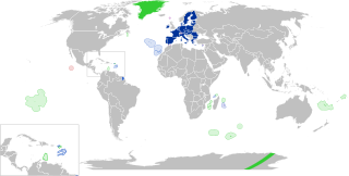
English:
European Union
Outermost regions
Overseas countries and territories
Special cases
Other special territories Français : Union européenne
Régions ultrapériphériques
Pays et territoires d'outre-mer
Cas spéciaux
Autres territoires spéciaux |
| Dátum | |
| Forrás | A feltöltő saját munkája |
| Szerző | Glentamara |
| SVG kód | Ez vektorgrafikus kép Inkscape segítségével készült, or with something else. |
Licenc
| Én, a szerző, ezt a művemet ezennel közkinccsé nyilvánítom. Ez a világ minden részén érvényes. Egyes országokban ez jogilag nem lehetséges. Ha így van, akkor: Jogot adok bárkinek, hogy bármilyen célból, feltétel nélkül használhassa ezt a fájlt, kivéve a törvény által kötelezően előírt feltételeket. |
Fájltörténet
Kattints egy időpontra, hogy a fájl akkori állapotát láthasd.
| Dátum/idő | Bélyegkép | Felbontás | Feltöltő | Megjegyzés | |
|---|---|---|---|---|---|
| aktuális | 2022. június 8., 21:12 | | 512 × 258 (835 KB) | Nablicus | new version |
| 2020. július 17., 12:13 |  | 512 × 259 (736 KB) | Alcaios | fixed – those were models I use to check the scale | |
| 2020. július 17., 01:03 |  | 512 × 258 (672 KB) | Nablicus | Reverted to version as of 19:08, 16 July 2020 (UTC). There is an extra UK and Iceland in the middle of Canada... | |
| 2020. július 16., 21:53 |  | 512 × 259 (753 KB) | Alcaios | frame | |
| 2020. július 16., 21:50 |  | 512 × 258 (681 KB) | Alcaios | minor fixed on Greenland mar. zone | |
| 2020. július 16., 21:46 |  | 512 × 258 (681 KB) | Alcaios | Added maritime zone of Gree,land based on https://www.marineregions.org/eezdetails.php?mrgid=8438 | |
| 2020. július 16., 21:32 |  | 512 × 259 (752 KB) | Alcaios | added Faroe Islands' maritime zone | |
| 2020. július 16., 21:08 |  | 512 × 258 (672 KB) | Alcaios | Maritime zones in the eastern Caribbean at the right scale, with the help of https://commons.wikimedia.org/wiki/File:Caribbean_maritime_boundaries_map.svg | |
| 2020. július 16., 20:44 |  | 512 × 259 (742 KB) | Alcaios | slight realignments | |
| 2020. július 16., 20:38 |  | 512 × 259 (742 KB) | Alcaios | typo in previous edit, read: "Northern Cyprus is not a special member state territory since..." –– the Åland archipelago is larger and almost reaches the Finnish coast |
Fájlhasználat
Az alábbi lap használja ezt a fájlt:
Globális fájlhasználat
A következő wikik használják ezt a fájlt:
- Használata itt: ar.wikipedia.org
- Használata itt: bew.wikipedia.org
- Használata itt: br.wikipedia.org
- Használata itt: cs.wikipedia.org
- Használata itt: de.wikipedia.org
- Használata itt: en.wikipedia.org
- European Union
- Neocolonialism
- Outline of the European Union
- Special territories of members of the European Economic Area
- Potential enlargement of the European Union
- External border of the European Union
- User:Xicomaia/sandbox
- User:Spinykitsune65/sandbox2
- User:A diehard editor/sandbox/EU infobox
- User:Falcaorib/World Alliances
- Használata itt: fa.wikipedia.org
- Használata itt: fr.wikipedia.org
- Aruba
- Ceuta
- Polynésie française
- Groenland
- Açores
- Saint-Pierre-et-Miquelon
- Îles Canaries
- Madère
- Îles Kerguelen
- Île Clipperton
- Îles Féroé
- Région ultrapériphérique
- Îles Éparses de l'océan Indien
- Curaçao
- Åland
- Melilla
- Archipel Crozet
- Terre Adélie
- Bonaire
- Saba
- Saint-Eustache (Antilles)
- Peñón de Vélez de la Gomera
- Peñón de Alhucemas
- Îles Saint-Paul et Amsterdam
- Plazas de soberanía
- Nouvelle-Calédonie
- Saint-Martin (royaume des Pays-Bas)
- Saint-Martin (Antilles françaises)
- Pays et territoire d'outre-mer
- Saint-Barthélemy (Antilles françaises)
- Union européenne
- États membres de l'Union européenne
A fájl globális használatának megtekintése