
Fájl:China-Qinghai.png
Nem érhető el nagyobb felbontású változat.
China-Qinghai.png (268 × 218 képpont, fájlméret: 15 KB, MIME-típus: image/png)
|
Ez a fájl a Wikimedia Commonsból származik. Az alább látható leírás az ottani dokumentációjának másolata. A Commons projekt szabad licencű kép- és multimédiatár. Segíts te is az építésében! |
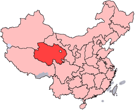
en: Location of Qinghai Province in the People's Republic of China. See Locator maps of province-level divisions of the People's Republic of China for more information.
zh: 青海省在中華人民共和國的位置。另見Locator maps of province-level divisions of the People's Republic of China。

|
Ez a fájl szabadon másolható, terjeszthető és/vagy módosítható a GNU Szabad Dokumentációs Licenc feltételei alapján, az 1.2 vagy későbbi, a Free Software Foundation által publikált Nem Változtatható szakaszok, Címlapszövegek és Hátlapszövegek nélküli változat szerint. E licenc egy példánya a GNU Szabad Dokumentációs Licenc című fejezetben olvasható. |
| Ez a fájl a Creative Commons Nevezd meg! – Így add tovább! 3.0 Unported licenc alapján használható fel. | ||
| ||
| Ez a licenc a GFDL licenccsere során került a fájlra. |
Fájltörténet
Kattints egy időpontra, hogy a fájl akkori állapotát láthasd.
| Dátum/idő | Bélyegkép | Felbontás | Feltöltő | Megjegyzés | |
|---|---|---|---|---|---|
| aktuális | 2005. július 15., 16:56 | | 268 × 218 (15 KB) | Schaengel89~commonswiki | transparent background |
| 2005. június 5., 00:39 |  | 268 × 218 (9 KB) | Ran | '''en''': Location of Qinghai Province in the People's Republic of China. See Category:Locator maps of province-level divisions of the People's Republic of China for more information. '''zh''': 青海省在中華人民共和國的位置。另見[[:C |
Fájlhasználat
Az alábbi lap használja ezt a fájlt:
Globális fájlhasználat
A következő wikik használják ezt a fájlt:
- Használata itt: cy.wikipedia.org
- Használata itt: da.wikipedia.org
- Használata itt: de.wikipedia.org
- Használata itt: en.wikipedia.org
- Wikipedia:WikiProject Chinese provinces/Locator maps
- Ledu, Haidong
- Henan Mongol Autonomous County
- Golmud Airport
- Template:Qinghai-geo-stub
- Bayan Har Mountains
- Wenquan, Golmud
- Mangra
- Zêkog County
- Tongren, Qinghai
- Jainca County
- 2008 Tibetan unrest
- Huzhu Tu Autonomous County
- Ping'an, Haidong
- Chengzhong, Xining
- Xireg
- Chengdong, Xining
- Chengbei, Xining
- Datong Hui and Tu Autonomous County
- Huangyuan County
- Huangzhong, Xining
- Hualong Hui Autonomous County
- Haiyan County, Qinghai
- Gangca County
- Menyuan Hui Autonomous County
- Gonghe County
- Tongde County
- Guide County
- Guinan County
- Maqên County
- Banma County
- Gadê County
- Darlag County
- Jigzhi County
- Madoi County
A fájl globális használatának megtekintése