
Fájl:Peedeerivermap.png
Nem érhető el nagyobb felbontású változat.
Peedeerivermap.png (500 × 415 képpont, fájlméret: 177 KB, MIME-típus: image/png)
|
Ez a fájl a Wikimedia Commonsból származik. Az alább látható leírás az ottani dokumentációjának másolata. A Commons projekt szabad licencű kép- és multimédiatár. Segíts te is az építésében! |

|
Ezt a képet el kellene készíteni vektorgrafika használatával SVG fájlként. A formátumnak számos előnye van; lásd a Commons:Media for cleanup lapot a további információkért. Ha a képnek már elérhető SVG-formátumú változata, töltsd fel. Az SVG feltöltése után cseréld le ezt a sablont a következőre: {{vector version available|új kép neve.svg}}.
|
Összefoglaló
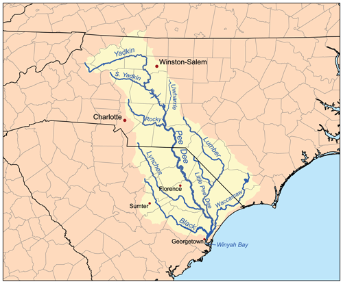
| Leírás | This is a map of the Pee Dee River watershed. I, Karl Musser, created it based on USGS data. |
| Dátum | 2007. február 28. (eredeti feltöltésének dátuma) |
| Forrás | Nincs megadva géppel olvasható forrás. Feltételezhetően saját munka (a szerzői jogi adatok alapján). |
| Szerző | Nincs megadva géppel olvasható szerző. Feltételezhetően Kmusser (a szerzői jogi adatok alapján). |
| Más változatok | File:Peedee-highrocklake.png |
Licenc
Én, e mű szerzője a művemet az alábbi licenc alatt teszem közzé:
Ez a fájl a Creative Commons Nevezd meg! – Így add tovább! 2.5 Általános licenc alapján használható fel.
- A következőket teheted a művel:
- megoszthatod – szabadon másolhatod, terjesztheted, bemutathatod és előadhatod a művet
- feldolgozhatod – származékos műveket hozhatsz létre
- Az alábbi feltételekkel:
- Nevezd meg! – A szerzőt megfelelően fel kell tüntetned, hivatkozást kell létrehoznod a licencre és jelezned kell, ha a művön változtatást hajtottál végre. Ezt bármilyen észszerű módon megteheted, kivéve oly módon, ami azt sugallná hogy a jogosult támogat téged vagy a felhasználásod körülményeit.
- Így add tovább! – Ha megváltoztatod, átalakítod, feldolgozod ezt a művet, a közreműködésedet csak az eredetivel megegyező vagy hasonló licenc alatt terjesztheted.
Fájltörténet
Kattints egy időpontra, hogy a fájl akkori állapotát láthasd.
| Dátum/idő | Bélyegkép | Felbontás | Feltöltő | Megjegyzés | |
|---|---|---|---|---|---|
| aktuális | 2007. február 28., 19:27 | | 500 × 415 (177 KB) | Kmusser | spelling fix |
| 2007. február 28., 19:02 |  | 500 × 415 (177 KB) | Kmusser | This is a map of the Pee Dee River watershed. I, Karl Musser, created it based on USGS data. {{self|cc-by-sa-2.5}} Category:Maps of rivers of the United States |
Fájlhasználat
Az alábbi lap használja ezt a fájlt:
Globális fájlhasználat
A következő wikik használják ezt a fájlt:
- Használata itt: ar.wikipedia.org
- Használata itt: arz.wikipedia.org
- Használata itt: bg.wikipedia.org
- Használata itt: ca.wikipedia.org
- Használata itt: da.wikipedia.org
- Használata itt: de.wikipedia.org
- Használata itt: en.wikipedia.org
- Pee Dee River
- Lynches River
- List of rivers of North Carolina
- Yadkin River
- List of rivers of South Carolina
- Waccamaw River
- Little Pee Dee River
- Black River (South Carolina)
- Johnsonville crater
- User:Kmusser/Images
- Lumber River
- Cheraw
- Rocky River (North Carolina)
- Yadkin–Pee Dee River Basin
- South Yadkin River
- User:Tisquesusa/sandbox9
- User:CarolineJS1963/sandbox/csc126/final
- Használata itt: es.wikipedia.org
- Használata itt: fr.wikipedia.org
- Használata itt: ja.wikipedia.org
- Használata itt: no.wikipedia.org
- Használata itt: pl.wikipedia.org
- Használata itt: ru.wikipedia.org
- Használata itt: simple.wikipedia.org
- Használata itt: uk.wikipedia.org
- Használata itt: www.wikidata.org